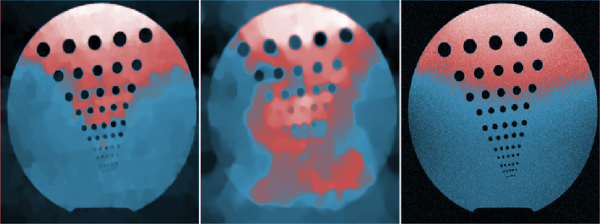
Most recent mobile mapping systems (MMS) capture 3D lidar point cloud together with HD optical images. In this talk, we will present a method to add color information to each lidar point. First, each lidar point is projected onto each color image. By comparing the depth of a point in one image with the ones of its neighbors in the same image, a visibility coefficient is automatically estimated for each point in each point of view/image. It provides a confidence index to the color of the corresponding pixel. Each point is thus associated to a list of color candidates and their index of confidence. The final color for each point is computed from spatial regularization on the point cloud domain.
This presentation is part of Minisymposium “MS27 - Color Imaging Meets Geometry”
organized by: Gabriele Steidl (University of Kaiserslautern) , Edoardo Provenzi (Université de Bordeaux) .
Bologna - Italy
Society for Industrial and Applied Mathematics
Photo used under Creative Commons.
Credits.
© BCIS18 2016 - Privacy
Bologna Committee for IS Conference 2018 (BCIS18)
Department of Mathematics
University of Bologna
Piazza di Porta San Donato, 5
40126 - Bologna - Italy